Schema
To work with the data base, it helps to understand its public schema. The landslides data base follows a simple, well‑structured layout. A screenshot is shown below:
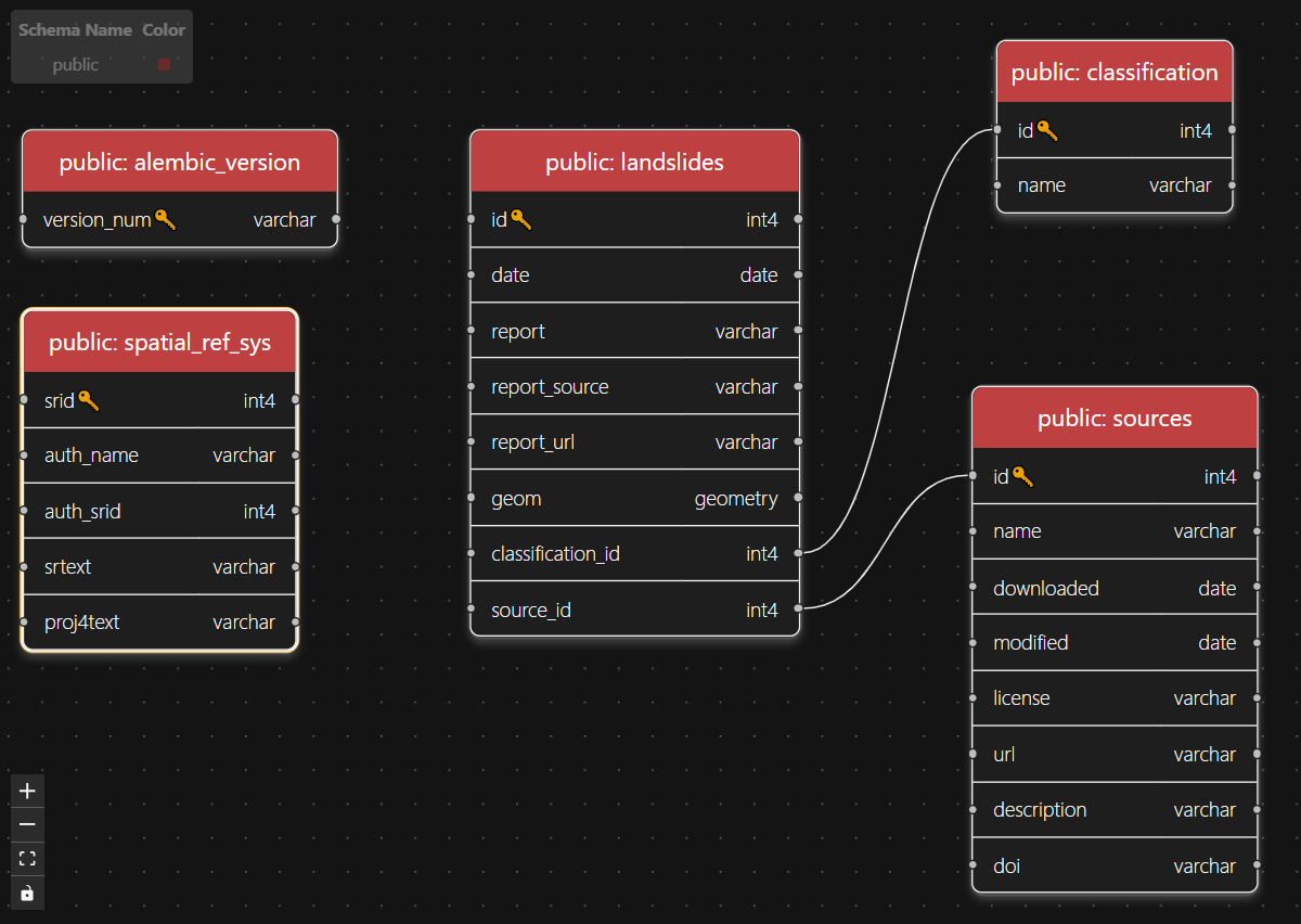
Each table is described in detail below.
Table Description
Let's break down each table and have a closer look.
| Table | Description |
|---|---|
alembic_version | Single row containing the Alembic migration version. |
spatial_ref_sys | Coordinate reference systems (CRS) available. |
landslides | Event records (e.g., rockfalls, debris flows, ...) with date and point geometry. |
classification | Lookup table with classification labels used by the landslides table. |
sources | Metadata about original data sources linked to event records. |
alembic_version
Migration of the data base is done with the Python package alembic. "Alembic provides for the creation, management, and invocation of change management scripts for a relational database, using SQLAlchemy as the underlying engine."[1]
The alembic_version table is automatically added by the tool, it serves as information.
INFO
Alembic is used to auto-generate the schema from the models defined with sqlalchemy. The alembic migration scripts are in alembic/versions/.
spatial_ref_sys
The spatial_ref_sys table is included in every PostGIS data base and stores coordinate reference system (CRS) definitions (SRID, proj4/WKT text). In PostGIS each geometry is linked to an SRID. For example, the landslides table contains events including point geometries (longitude, latitude) that are linked to an SRID. The spatial_ref_sys table is used to interpret that SRID.
landslides
The landslides table contains the mass movement events, including a event date (date) and point geometry (geom). All records are linked to source and classification via the source_id and classification_id respectively. Find the first two records below:
| id | date | geom | source_id | report | report_source | report_url | classification_id |
|---|---|---|---|---|---|---|---|
| 1 | 2024-11-01 | 0101000020787F... | 1 | NULL | NULL | NULL | 1 |
| 2 | 2024-10-22 | 0101000020787F... | 1 | NULL | NULL | NULL | 1 |
Details
The SQL query for above table:
SELECT *
FROM public.landslides
LIMIT 2;
Column Overview
Some fields are nullable whereas other must always be present, see below table for an overview.
| Field | Nullable | Description |
|---|---|---|
| date | No | Event date |
| geom | No | Point geometry in EPSG:32632 |
| source_id | No | Foreign key to the sources table |
| report | Yes | Optional report describing the event |
| report_source | Yes | Optional name of the report source |
| report_url | Yes | Optional URL linking to the original report/resource |
| classification_id | No | Foreign key to the classification table |
INFO
Geometries are all in EPSG:32632!
In short, date, geom and source_id and classification_id are always present.
INFO
By default, the point geometry geom is returned as hex-encoded binary. To get the geometry as string, use the ST_AsText function. For example:
SELECT id, date, ST_AsText(geom) AS wkt
FROM public.landslides
LIMIT 2;| id | date | wkt |
|---|---|---|
| 1 | 2024-11-01 | POINT(748676.21304 5272749.179051) |
| 2 | 2024-10-22 | POINT(641802.697946 5196727.447737) |
TIP
With the ST_AsEWKT function, the SRID can be included as well.
SELECT id, ST_AsEWKT(geom) AS ewkt
FROM public.landslides
LIMIT 2;| id | date | wkt |
|---|---|---|
| 1 | 2024-11-01 | SRID=32632;POINT(748676.21304 5272749.179051) |
| 2 | 2024-10-22 | SRID=32632;POINT(641802.697946 5196727.447737) |
classification
This table stores the classification labels referenced by the landslides table (via classification_id). The available values are listed below:
| name |
|---|
| rockfall |
| collapse, sinkhole |
| mass movement (undefined type) |
| gravity slide or flow |
| deep seated rock slope deformation |
Each record is classified into one of these categories. The categories itself were derived from the GeoSphere data set (see Data Sources for more info).
Details
The corresponding query to the above table:
SELECT name
FROM public.classification;
sources
The sources table stores metadata for each original data set referenced by landslides. It captures provenance, access details and licensing to ensure traceability and reproducibility. The id column is referenced by landslides.source_id.
| Field | Nullable | Description |
|---|---|---|
| name | No | Source name (data set title or institution) |
| downloaded | No | Date the data set was retrieved |
| modified | Yes | Optional: last modified date from the provider |
| license | No | License type of the source |
| url | No | Link to the original data set or metadata page |
| description | Yes | Optional: Short, human‑readable summary of the data set |
| doi | Yes | Optional: persistent identifier (DOI) |
Views
landslides_view
For convenience, a view, called landslides_view, is available that encompasses information from all three tables (landslides, classification, sources). The view provides information on all mass movement phenomena in the data base including their source information and classification.
TIP
If you are looking for an entry point to the data base, use this view.
Retrieve everything with:
SELECT *
FROM landslides_view;
INFO
As an optional (Docker) service a API is provided which could serve as an entry point for further applications. The API serves data from this landslides_view. See the Quick Start section for more details.